Geopolitik is the branch of uniquely German geostrategy. It developed as a distinct strain of thought after Otto von Bismarck's unification of the German states but began its development in earnest only under Emperor Wilhelm II.
 |
| Emperor Wilhelm II |
Wilhelm II was the last German Emperor (Kaiser) and King of Prussia, ruling the German Empire and the Kingdom of Prussia from 15 June 1888 to 9 November 1918. He was the eldest grandchild of the Queen Victoria of the United Kingdom and related to many monarchs and princes of Europe, most notably King George V ...
GEOPOLITICA
Geopolitics (from Greek γῆ gê "earth, land" and πολιτική politikḗ "politics") is the study of the effects of geography (human and physical) on politics and international relations.[1] While geopolitics usually refers to countries and relations between them, it may also focus on two other kinds of states: de facto independent states with limited international recognition and; relations between sub-national geopolitical entities, such as the federated states that make up a federation, confederation or a quasi-federal system.
At the level of international relations, geopolitics is a method of studying foreign policy to understand, explain and predict international political behavior through geographical variables. These include area studies, climate, topography, demography, natural resources, and applied science of the region being evaluated.[2]
Geopolitics focuses on political power in relation to geographic space. In particular, territorial waters and land territory in correlation with diplomatic history. Academically, geopolitics analyses history and social science with reference to geography in relation to politics. Outside academia, a variety of groups offer a geopolitical prognosis, including non-profit groups and for-profit private institutions (such as brokerage houses[3] and consulting companies[4]).
Topics of geopolitics include relations between the interests of international political actors, interests focused to an area, space, geographical element or ways, relations which create a geopolitical system.[5] "Critical geopolitics" deconstructs classical geopolitical theories, by showing their political/ideological functions for great powers during and after the age of imperialism.[6]
According to Christopher Gogwilt and other researchers the term is currently being used to describe a broad spectrum of ideas, in a general sense used as "a synonym for internal political relations", but more specifically "to imply the global structure of such relations", which builds on "early-twentieth-century term for a pseudoscience of political geography" and other pseudoscientific theories of historical and geographic determinism
United States
Alfred Thayer Mahan and sea power
Alfred Thayer Mahan (1840–1914), a frequent commentator on world naval strategic and diplomatic affairs, believed that national greatness was inextricably associated with the sea—and particularly with its commercial use in peace and its control in war. Mahan's theoretical framework came from Antoine-Henri Jomini, and emphasized that strategic locations (such as chokepoints, canals, and coaling stations), as well as quantifiable levels of fighting power in a fleet, were conducive to control over the sea. He proposed six conditions required for a nation to have sea power:
Advantageous geographical position;
Serviceable coastlines, abundant natural resources, and favorable climate;
Population large enough to defend its territory;
Society with an aptitude for the sea and commercial enterprise; and
Government with the influence and inclination to dominate the sea.[10]
Mahan distinguished a key region of the world in the Eurasian context, namely, the Central Zone of Asia lying between 30° and 40° north and stretching from Asia Minor to Japan.[11] In this zone independent countries still survived – Turkey, Persia, Afghanistan, China, and Japan. Mahan regarded those countries, located between Britain and Russia, as if between "Scylla and Charybdis". Of the two monsters – Britain and Russia – it was the later that Mahan considered more threatening to the fate of Central Asia. Mahan was impressed by Russia's transcontinental size and strategically favorable position for southward expansion. Therefore, he found it necessary for the Anglo-Saxon "sea power" to resist Russia.[12]
Emil Reich
The Austro-Hungarian historian Emil Reich (1854–1910) is considered to be the first having coined the acceptance in English[13] as early as 1902 and later in 1904 in his book Foundations of Modern Europe.[14]
Homer Lea
Homer Lea in The Day of the Saxon (1912) described that the entire Anglo-Saxon race faced a threat from German (Teuton), Russian (Slav), and Japanese expansionism: The "fatal" relationship of Russia, Japan, and Germany "has now assumed through the urgency of natural forces a coalition directed against the survival of Saxon supremacy." It is "a dreadful Dreibund".[15] Lea believed that while Japan moved against Far East and Russia against India, the Germans would strike at England, the center of the British Empire. He thought the Anglo-Saxons faced certain disaster from their militant opponents.
Mackinder and the Heartland theory
Sir Halford Mackinder's Heartland concept showing the situation of the "pivot area" established in the Theory of the Heartland. He later revised it to mark Northern Eurasia as a pivot while keeping area marked above as Heartland.
Sir Halford Mackinder's Heartland Theory initially received little attention outside geography, but some thinkers would claim that it subsequently influenced the foreign policies of world powers.[16] Those scholars who look to MacKinder through critical lenses accept him as an organic strategist who tried to build a foreign policy vision for Britain with his Eurocentric analysis of historical geography.[17] His formulation of the Heartland Theory was set out in his article entitled "The Geographical Pivot of History", published in England in 1904.
Mackinder's doctrine of geopolitics involved concepts diametrically opposed to the notion of Alfred Thayer Mahan about the significance of navies (he coined the term sea power) in world conflict. He saw navy as a basis of Colombian era empire (roughly from 1492 to the 19th century), and predicted the 20th century to be domain of land power. The Heartland theory hypothesized a huge empire being brought into existence in the Heartland—which wouldn't need to use coastal or transoceanic transport to remain coherent.
The basic notions of Mackinder's doctrine involve considering the geography of the Earth as being divided into two sections: the World Island or Core, comprising Eurasia and Africa; and the Peripheral "islands", including the Americas, Australia, Japan, the British Isles, and Oceania. Not only was the Periphery noticeably smaller than the World Island, it necessarily required much sea transport to function at the technological level of the World Island—which contained sufficient natural resources for a developed economy.
Mackinder posited that the industrial centers of the Periphery were necessarily located in widely separated locations. The World Island could send its navy to destroy each one of them in turn, and could locate its own industries in a region further inland than the Periphery (so they would have a longer struggle reaching them, and would face a well-stocked industrial bastion). Mackinder called this region the Heartland. It essentially comprised Central and Eastern Europe: Ukraine, Western Russia, and Mitteleuropa.[18] The Heartland contained the grain reserves of Ukraine, and many other natural resources. Mackinder's notion of geopolitics was summed up when he said:
Who rules Central and Eastern Europe commands the Heartland. Who rules the Heartland commands the World-Island. Who rules the World-Island commands the World.
Nicholas J. Spykman is both a follower and critic of geostrategists Alfred Mahan, and Halford Mackinder. His work is based on assumptions similar to Mackinder's,[19] including the unity of world politics and the world sea. He extends this to include the unity of the air. Spykman adopts Mackinder's divisions of the world, renaming some:
The Heartland;
The Rimland (analogous to Mackinder's "inner or marginal crescent" also an intermediate region, lying between the Heartland and the marginal sea powers); and
The Offshore Islands & Continents (Mackinder's "outer or insular crescent").[20]
Under Spykman's theory, a Rimland separates the Heartland from ports that are usable throughout the year (that is, not frozen up during winter). Spykman suggested this required that attempts by Heartland nations (particularly Russia) to conquer ports in the Rimland must be prevented. Spykman modified
Mackinder's formula on the relationship between the Heartland and the Rimland (or the inner crescent), claiming that "Who controls the rimland rules Eurasia. Who rules Eurasia controls the destinies of the world." This theory can be traced in the origins of Containment, a U.S. policy on preventing the spread of Soviet influence after World War II (see also Truman Doctrine).
Another famous follower of Mackinder was Karl Haushofer who called Mackinder's Geographical Pivot of History a "genius' scientific tractate."[21] He commented on it: "Never have I seen anything greater than those few pages of geopolitical masterwork."[22] Mackinder located his Pivot, in the words of Haushofer, on "one of the first solid, geopolitically and geographically irreproachable maps, presented to one of the earliest scientific forums of the planet – the Royal Geographic Society in London"[23] Haushofer adopted both Mackinder's Heartland thesis and his view of the Russian-German alliance – powers that Mackinder saw as the major contenders for control of Eurasia in the twentieth century. Following Mackinder he suggested an alliance with the Soviet Union and, advancing a step beyond Mackinder, added Japan to his design of the Eurasian Bloc.[24]
In 2004, at the centenary of The Geographical Pivot of History, famous Historian Paul Kennedy wrote: "Right now with hundreds of thousands of US troops in the Eurasian rimlands and with administration constantly explaining why it has to stay the course, it looks as if Washington is taking seriously Mackinder's injunction to ensure control of the geographical pivot of history."[25]
Kissinger, Brzezinski and the Grand Chessboard
World map with the concepts of Heartland and Rimland applied.
Two famous Security Advisers from the Cold War period, Henry Kissinger and Zbigniew Brzezinski, cared lest the United States lose its geopolitical focus on Eurasia and, first and foremost, on Russia despite the fall of Communism and the end of the ideological struggle. Ideological Cold warriors, both turned into convinced geopoliticians after the end of the Cold War,[26] and each wrote an influential book on the subject in the 1990s—Diplomacy (Kissinger 1994) and The Grand Chessboard: American Primacy and Its Geostrategic Imperatives.[27] The Anglo-American classical geopolitical theories were revived.
Students of geopolitics and history, Kissinger wrote in Diplomacy, are uneasy about the approach that hostile intentions have disappeared and traditional foreign policy considerations no longer apply. "They would argue … that Russia, regardless of who govern it, sits astride the territory Halford Mackinder called the geopolitical heartland, and is the heir to one of the most potent imperial traditions." The United States must "maintain the global balance of power vis-à-vis the country with a long history of expansionism."[28]
After Russia, the second geopolitical threat traditionally remained Germany and, as Mackinder had feared ninety years ago, its partnership with Russia. During the Cold War, Kissinger argues, both sides of the Atlantic recognized that, "unless America is organically involved in Europe, it would be obliged to involve itself later under circumstances far less favorable to both sides of the Atlantic. That is even more true today.
Germany has become so strong that existing European institutions cannot by themselves strike a balance between Germany and its European partners. Nor can Europe, even with Germany, manage by itself … Russia…" It is in no country's interest that Germany and Russia should fixate on each other as principal partner. They would raise fears of condominium.[clarification needed] Without America, Britain and France cannot cope with Germany and Russia; and "without Europe, America could turn … into an island off the shores of Eurasia."[29]
Spykman's vision of Eurasia was strongly confirmed: "Geopolitically, America is an island off the shores of the large landmass of Eurasia, whose resources and population far exceed those of the United States. The domination by a single power of either of Eurasia's two principal spheres—Europe and Asia—remains a good definition of strategic danger for America. Cold War or no Cold War. For such a grouping would have the capacity to outstrip America economically and, in the end, militarily. That danger would have to be resisted even were the dominant power apparently benevolent, for if the intentions ever changed, America would find itself with a grossly diminished capacity for effective resistance and a growing inability to shape events."[30] The main interest of the American leaders is maintaining the balance of power in Eurasia[31]
Having converted from ideologist into geopolitician, Kissinger in retrospect interpreted the Cold War in geopolitical terms—an approach not characteristic for his works during the Cold War. Now, however, he stressed on the beginning of the Cold War: "The objective of moral opposition to Communism had merged with the geopolitical task of containing the Soviet expansion."[32] Nixon, he added, was geopolitical rather than ideological cold warrior.[33]
Three years after Kissinger's Dilpomacy, Brzezinski followed suit, launching The Grand Chessboard: American Primacy and Its Geostrategic Imperatives and, after three more years, The Geostrategic Triad: Living with China, Europe, and Russia. The Grand Chessboard described the American triumph in the Cold War in terms of control over Eurasia: for the first time ever, a "non-Eurasian" power had emerged as a key arbiter of "Eurasian" power relations.[34] The book states its purpose:
"The formulation of a comprehensive and integrated Eurasian geostrategy is therefore the purpose of this book."[35] Although the power configuration underwent a revolutionary change, Brzezinski confirmed three years later, Eurasia was still a megacontinent.[36] Like Spykman, Brzezinski acknowledges that: "Cumulatively, Eurasia's power vastly overshadows America's."[34]
In classical Spykman terms, Brzezinski formulized his geostrategic "chessboard" doctrine of Eurasia, which aims to prevent the unification of this megacontinent.
"Europe and Asia are politically and economically powerful…. It follows that… American foreign policy must…employ its influence in Eurasia in a manner that creates a stable continental equilibrium, with the United States as the political arbiter.…
Eurasia is thus the chessboard on which the struggle for global primacy continues to be played, and that struggle involves geo- strategy – the strategic management of geopolitical interests…. But in the meantime it is imperative that no Eurasian challenger emerges, capable of dominating Eurasia and thus also of challenging America… For America the chief geopolitical prize is Eurasia…and America's global primacy is directly dependent on how long and how effectively its preponderance on the Eurasian continent is sustained."[37]
Germany
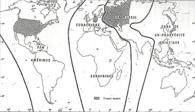
Division of the world according to Haushofer's Pan-Regions Doctrine
German Geopolitik is characterized by the belief that life of States—being similar to those of human beings and animals—is shaped by scientific determinism and social Darwinism. German geopolitics develops the concept of Lebensraum (living space) that is thought to be necessary to the development of a nation like a favorable natural environment would be for animals.
Friedrich Ratzel
Friedrich Ratzel (1844–1904), influenced by thinkers such as Darwin and zoologist Ernst Heinrich Haeckel, contributed to 'Geopolitik' by the expansion on the biological conception of geography, without a static conception of borders.
Positing that states are organic and growing, with borders representing only a temporary stop in their movement, he held that the expanse of a state's borders is a reflection of the health of the nation—meaning that static countries are in decline.
Ratzel published several papers, among which was the essay "Lebensraum" (1901) concerning biogeography. Ratzel created a foundation for the German variant of geopolitics, geopolitik. Influenced by the American geostrategist Alfred Thayer Mahan, Ratzel wrote of aspirations for German naval reach, agreeing that sea power was self-sustaining, as the profit from trade would pay for the merchant marine, unlike land power.
The geopolitical theory of Ratzel has been criticized as being too sweeping, and his interpretation of human history and geography being too simple and mechanistic. Critically, he also underestimated the importance of social organization in the development of power.[38]
The association of German Geopolitik with Nazism
After World War I, the thoughts of Rudolf Kjellén and Ratzel were picked up and extended by a number of German authors such as Karl Haushofer (1869–1946), Erich Obst, Hermann Lautensach and Otto Maull. In 1923, Karl Haushofer founded the Zeitschrift für Geopolitik (Journal for Geopolitics), which was later used in the propaganda of Nazi Germany. The key concepts of Haushofer's Geopolitik were Lebensraum, autarky, pan-regions, and organic borders. States have, Haushofer argued, an undeniable right to seek natural borders which would guarantee autarky.
Haushofer's influence within the Nazi Party has recently been challenged,[39] given that Haushofer failed to incorporate the Nazis' racial ideology into his work. Popular views of the role of geopolitics in the Nazi Third Reich suggest a fundamental significance on the part of the geo-politicians in the ideological orientation of the Nazi state. Bassin (1987) reveals that these popular views are in important ways misleading and incorrect.
Despite the numerous similarities and affinities between the two doctrines, geopolitics was always held suspect by the National Socialist ideologists. This was understandable, for the underlying philosophical orientation of geopolitics did not comply with that of National Socialism. Geopolitics shared Ratzel's scientific materialism and geographic determinism, and held that human society was determined by external influences—in the face of which qualities held innately by individuals or groups were of reduced or no significance.
National Socialism rejected in principle both materialism and determinism and also elevated innate human qualities, in the form of a hypothesized 'racial character,' to the factor of greatest significance in the constitution of human society. These differences led after 1933 to friction and ultimately to open denunciation of geopolitics by Nazi ideologues.[40] Nevertheless, German Geopolitik was discredited by its (mis)use in Nazi expansionist policy of World War II and has never achieved standing comparable to the pre-war period.
The resultant negative association, particularly in U.S. academic circles, between classical geopolitics and Nazi or imperialist ideology, is based on loose justifications. This has been observed in particular by critics of contemporary academic geography, and proponents of a "neo"-classical geopolitics in particular. These include Haverluk et al., who argue that the stigmatization of geopolitics in academia is unhelpful as geopolitics as a field of positivist inquiry maintains potential in researching and resolving topical, often politicized issues such as conflict resolution and prevention, and mitigating climate change.[41]
Disciplinary differences in perspectives
Negative associations with the term "geopolitics" and its practical application stemming from its association with World War II and pre-World War II German scholars and students of Geopolitics are largely specific to the field of academic Geography, and subdisciplines of Human Geography such as Political Geography in particular. However, this negative association does not exist, or at least not to the same extent, in disciplines such as History or Political Science that make use of geopolitical concepts.
Classical Geopolitics forms an important element of analysis for Military History as well as for subdisciplines of Political Science such as International Relations and Security Studies. This difference in disciplinary perspectives is addressed by Bert Chapman in Geopolitics: A Guide To the Issues, in which Chapman makes note that academic and professional International Relations journals are more amenable to the study and analysis of Geopolitics, and in particular Classical Geopolitics, than contemporary academic journals in the field of Political Geography.[42]
In disciplines outside Geography, Geopolitics is not negatively viewed (as it often is among academic geographers such as Carolyn Gallaher or Klaus Dodds) as a tool of Imperialism or associated with Nazism, but rather viewed as a valid and consistent manner of assessing major international geopolitical circumstances and events, not necessarily related to armed conflict or military operations.
France
This section needs additional citations for verification. Please help improve this article by adding citations to reliable sources. Unsourced material may be challenged and removed. (May 2013) (Learn how and when to remove this template message)
French geopolitical doctrines lie broadly in opposition to German Geopolitik and reject the idea of a fixed geography. French geography is focused on the evolution of polymorphic territories being the result of mankind's actions. It also relies on the consideration of long time periods through a refusal to take specific events into account. This method has been theorized by Professor Lacoste according to three principles: Representation; Diachronie; and Diatopie.
In The Spirit of the Laws, Montesquieu outlined the view that man and societies are influenced by climate. He believed that hotter climates create hot-tempered people and colder climates aloof people, whereas the mild climate of France is ideal for political systems. Considered as one of the founders of French geopolitics, Élisée Reclus, is the author of a book considered as a reference in modern geography (Nouvelle Géographie universelle). Alike Ratzel, he considers geography through a global vision. However, in complete opposition to Ratzel's vision, Reclus considers geography not to be unchanging; it is supposed to evolve commensurately to the development of human society. His marginal political views resulted in his rejection by academia.
French geographer and geopolitician Jacques Ancel is considered to be the first theoretician of geopolitics in France, and gave a notable series of lectures at the European Center of the Carnegie Endowment for International Peace in Paris and published Géopolitique in 1936. Like Reclus, Ancel rejects German determinist views on geopolitics (including Haushofer's doctrines).
Braudel's broad view used insights from other social sciences, employed the concept of the longue durée, and downplayed the importance of specific events.
This method was inspired by the French geographer Paul Vidal de la Blache (who in turn was influenced by German thought, particularly that of Friedrich Ratzel whom he had met in Germany). Braudel's method was to analyse the interdependence between individuals and their environment.[43] Vidalian geopolitics is based on varied forms of cartography and on possibilism (founded on a societal approach of geography—i.e. on the principle of spaces polymorphic faces depending from many factors among them mankind, culture, and ideas) as opposed to determinism.
Due to the influence of German Geopolitik on French geopolitics, the latter were for a long time banished from academic works. In the mid-1970s, Yves Lacoste—a French geographer who was directly inspired by Ancel, Braudel and Vidal de la Blache—wrote La géographie, ça sert d'abord à faire la guerre (Geography first use is war) in 1976. This book—which is very famous in France—symbolizes the birth of this new school of geopolitics (if not so far the first French school of geopolitics as Ancel was very isolated in the 1930s–40s). Initially linked with communist party evolved to a less liberal approach.
At the end of the 1980s he founded the Institut Français de Géopolitique (French Institute for Geopolitics) that publishes the Hérodote revue. While rejecting the generalizations and broad abstractions employed by the German and Anglo-American traditions (and the new geographers), this school does focus on spatial dimension of geopolitics affairs on different levels of analysis. This approach emphazises the importance of multi-level (or multi-scales) analysis and maps at the opposite of critical geopolitics which avoid such tools. Lacoste proposed that every conflict (both local or global) can be considered from a perspective grounded in three assumptions:
Representation: Each group or individuals is the product of an education and is characterized by specific representations of the world or others groups or individuals. Thus, basic societal beliefs are grounded in their ethnicity or specific location. The study of representation is a common point with the more contemporary critical geopolitics. Both are connected with the work of Henri Lefebvre (La production de l'espace, first published in 1974)
Diachronie. Conducting an historical analysis confronting "long periods" and short periods as the prominent French historian Fernand Braudel suggested.
Diatopie: Conducting a cartographic survey through a multiscale mapping.
Connected with this stream, and former member of Hérodote editorial board, the French geographer Michel Foucher developed a long term analysis of international borders. He coined various neologism among them: Horogenesis: Neologism that describes the concept of studying the birth of borders, Dyade: border shared by two neighbouring states (for instance US territory has two terrestrial dyades : one with Canada and one with Mexico). The main book of this searcher "Fronts et frontières" (Fronts and borders) first published in 1991, without equivalent remains as of yet untranslated in English. Michel Foucher is an expert of the African Union for borders affairs.
More or less connected with this school, Stéphane Rosière can be quoted as the editor in Chief of the online journal L'Espace politique,[44] this journal created in 2007 became the most prominent French journal of political geography and Geopolitics with Hérodote.
A much more conservative stream is personified by François Thual. Thual was a French expert in geopolitics, and a former official of the Ministry of Civil Defence. Thual taught geopolitics of the religions at the French War College, and has written thirty books devoted mainly to geopolitical method and its application to various parts of the world. He is particularly interested in the Orthodox, Shiite, and Buddhist religions, and in troubled regions like the Caucasus. Connected with F. Thual, Aymeric Chauprade, former professor of geopolitics at the French War College and now member of the extreme-right party "Front national", subscribes to a supposed "new" French school of geopolitics which advocates above all a return to realpolitik and "clash of civilization" (Huntington).
The thought of this school is expressed through the French Review of Geopolitics (headed by Chauprade) and the International Academy of Geopolitics. Chauprade is a supporter of a Europe of nations, he advocates a European Union excluding Turkey, and a policy of compromise with Russia (in the frame of a Eurasian alliance which is en vogue among European extreme-right politists) and supports the idea of a multipolar world—including a balanced relationship between China and the U.S.
Russia
In the 1990s a senior researcher at the Institute of Philosophy, Russian Academy of Sciences of the Russian Academy of Sciences, Vadim Tsymbursky ( ru ) (1957-2009), coined the term "island-Russia" and developed the "Great Limitrophe" concept.[citation needed]
Colonel-General Leonid Ivashov (retired), a Russian geopolitics specialist of the early 21st century, headed the Academy of Geopolitical Problems (Russian: Академия геополитических проблем), which analyzes the international and domestic situations and develops geopolitical doctrine. Earlier, Colonel-General Leonid Ivashov headed the Main Directorate for International Military Cooperation of the Ministry of Defence of the Russian Federation.
Vladimir Karyakin, Leading Researcher at the Russian Institute of Strategic Studies (ru), has proposed the term "geopolitics of the third wave".[45][clarification needed]
Meta-geopolitics
The framework of Meta-geopolitics, proposed by Nayef Al-Rodhan combines traditional and new dimensions of geopolitics to offer a multidimensional view of power and power relationships.[46] In this framework, the importance of geography is superseded by the combination of hard- and soft- power tools that states can employ to preserve and obtain power. Meta-geopolitics defines seven key dimensions of state power that include social and health issues, domestic politics, economics, environment, science and human potential, military and security issues, and international diplomacy.[47]
The Meta-geopolitics framework allows for the assessment of relative strengths and weaknesses as well as predictions about future trends. Furthermore, while this analytical grid is relevant for states, it also applies to private and transnational entities, which are playing an increasingly important role in contemporary geopolitics.[48]
https://www.tandfonline.com/doi/abs/10.1080/01402399908437762?journalCode=fjss20





One thought on “LA CUESTIÓN FRONTERIZA PERÚ-CHILE: UN REACTIVADO FOCO DE TENSIÓN”